เจ้าบ้านคร้าบบบบ

เจ้าบ้านคร้าบบบบ

หาดแม่รำพึง


หาดแม่รำพึง หรือก้นอ่าว ที่เป็นที่นิยมของคนชอบอาหารทะเล ตลอดแนวหาดเป็นสิบกิโลเมตร ทั้งสองข้างทางเต็มไปด้วยร้านอาหารทะเลสดๆ และบังกะโล รีสอร์ท คอนโดมิเนียม หาดแห่งนี้ มีนักท่องเที่ยวแวะมาตลอดปีทั้งตั้งใจมาพักและเพียงทางผ่านก่อนกลับกรุงเทพ เพื่อมาทานอาหารทะเลสดๆ และเป็นที่นิยมของชาวระยองเองด้วย บรรยากาศริมทะเลหาดทรายยาวสุดลูกหูลูกตา แนวสน และลมทะเล วันหยุดวันพักผ่อนสั้นๆก็จะเดินทางมาเพื่อสังสรรค์กับเพื่อนฝูงหรือครอบครับ

หาดแม่รำพึงอยู่บนถนนสุขุมวิท ก่อนถึงบ้านเพ เพียงไม่กี่กิโลเมตร จะมีทางแยกเพื่อเข้าหาด ออกจากระยองมาเพียง10กว่ากิโลเท่านั้น ช่วงที่น่าเที่ยวก็คงหนีไม่พ้นในหน้าร้อน แต่หาดแห่งนี้ก็ไม่ขาดนักท่องเที่ยวแม้ในฤดูฝน อาจเพราะเนื่องจากการเดินทางที่สะดวกไม่กี่ชั่วโมงจากกรุงเทพ และเรื่องอาหารทะเลที่เป็นแหล่งรวมร้านอาหารชื่อดังมากมาย

ลานหินขาว ตั้งอยู่ระหว่างกลางของหาดแม่รำพึง ถูกจัดเป็นสวนหินมีที่นั่งพัก เย็นๆจะเห็นนักท่องเที่ยวแวะมานั่งเล่นมากมายรวมทั้งชาวบ้านแถบนี้เองด้วย
วันหยุดนี้น่าลองมาหาอาหารทะเลสดๆทานกับครอบครัว หรือเพื่อนฝูงมากทีเดียว ร้านอาหารแถบนี้มีมากจนรับนักชิมได้ไม่จำกัน ส่วนใครชอบร้านไหน เลือกกันได้ตามสบายเลยครับ

อุทยานแห่งชาติหมู่เกาะสุรินทร์


อุทยานแห่งชาติหมู่เกาะสุรินทร์ ตั้งชื่อตามพระยาสุรินทราชา (นกยูง วิเศษกุล) เทศาเมืองภูเก็ต ผู้ค้นพบเกาะ เป็นอุทยานแห่งชาติที่ตั้งอยู่ในเขตจังหวัดพังงา มีลักษณะเป็นหมู่เกาะในทะเลอันดามัน อยู่ติดกับชายแดน ไทย - พม่า มีพื้นที่ประมาณ 84375 ไร่ ร้อยละ 76 ของพื้นที่เป็นทะเล ส่วนที่เหลือเป็นแผ่นดิน ประกอบด้วยเกาะ 5 เกาะ คือ เกาะสุรินทร์เหนือ เกาะสุรินทร์ใต้ เกาะไข่ (เกาะตอรินลา) เกาะกลาง (เกาะปาจุมบา) เกาะรี (เกาะสต๊อก) และ 1 กองหินปริ่มน้ำ คือกองหินริเชลิว เป็นอุทยานแห่งชาติเมื่อวันที่ 9 กรกฎาคม พ.ศ. 2524 เป็นอุทยานแห่งชาติลำดับที่ 29 ของประเทศไทย

อุทยานแห่งชาติหมู่เกาะสุรินทร์นับว่ามีธรรมชาติที่สมบูรณ์ทั้งบนบกและใน ทะเล มีทั้งป่าดิบชื้น ป่าชายหาด ป่าชายเลนมาประจบกับแนวปะการัง แนวปะการังมี ความสมบูรณ์ เหมาะสำหรับชมปะการังน้ำตื้น โดยกองหินริเชริว เหมาะสำหรับดำน้ำลึก เป็นแหล่งสมบูรณ์ด้วยธรรมชาติใต้ทะเล มีปลาหลายชนิด มีโอกาสพบฉลามวาฬ ช่วงเวลาที่เหมาะกับการท่องเที่ยว คือ เดือนพฤษจิกายนถึง เดือนเมษายน และ หอยมือเสือ ปูเสฉวน นกกระแตผีชายหาด นกชาปีไหน รวมทั้งสัตว์เลี้ยงลูกด้วยนม เช่น บ่าง[3]

หมู่เกาะสุรินทร์ จะเป็นเกาะที่วางตัวอยู่ในกลุ่มอ่าวขนาดใหญ่ ดังนั้นจึงสามารถที่จะเป็น ที่บังคลื่นลมได้ดี ทั้งสองฤดู คือ ฤดูร้อน และฤดูฝน จึงเป็นแหล่งกำเนิดแนวปะการังน้ำตื้น ที่มีความอุดมสมบูรณ์ และมีขนาดใหญ่ที่สุดของประเทศไทย นอกจากนี้ยังมีหมู่บ้านของชาวเลเลกลุ่มสุดท้ายที่ยังดำรงวัฒนธรรมดั้งเดิม มากที่สุด คือ "มอแกน" หรือ "ยิบซีแห่งท้องทะเล" ประมาณ 200 คนปัจจุบันได้ตั้งหมู่บ้านอยู่ที่เกาะสุรินทร์ใต้ ขายของที่ระลึกให้นักท่องเที่ยว และบางส่วนทำงานเป็นลูกจ้างของอุทยานฯ

KOH LANTA

KOH LANTA THAILAND

http://www.voyage-phuket.com/IMAGE-FORFAITS/THAILAND-KOH-LANTA.jpg
Koh Lanta is delightfully exotic, thanks to its remote location, pristine beaches and balmy weather. It comprises 52 islands in the southernmost region of Thailand's Krabi Province, of which the largest and best-known is Koh Lanta Yai. The island is approximately seventy kilometres from Krabi, and offers an appealing escape from highly popular tourist destinations like Phuket and Phi Phi. http://www.kbo.moph.go.th/~sso_lanta/image/Koh-Lanta-map.gif

Once a backpacker's haven, Koh Lanta Yai nowadays sports several exclusive resorts. Friendly locals and its unspoiled nature are still main attractions. http://images.smh.com.au/2009/02/11/379029/420-Koh-Lanta-Thailand-420x0.jpg
Misty mountains abound in some areas, especially down south, while the islands' lush jungle, clean sandy beaches, pretty coral reefs and crystal-clear water make for a relaxing retreat. http://www.yourthaiplanet.com/beaches/KohLanta.jpg

Ranong Beaches

Despite being a small province, Ranong is abundant with natural attractions; the sea, islands, mountains, forests, waterfalls, mangroves forests. Yet, it is barely known among overseas tourists. This lush and rainy province bordering southern Myanmar , Ranong has among its attractions hot springs and stunning marine parkland. Indeed, this province offers a lot more than just another coastal province.

Chinese Influence
Bordering southern Myanmar and 600 kilometres south of Bangkok , mountainous Ranong Province receives more rain than elsewhere in Thailand , covering it in lush greenery. Ranong town began as a Chinese Hokkien settlement, and this is evident from its older architecture. One example is Nai Khai Ranong, the former home of Koh Su Chiang, a Hokkien governor of Ranong during the reign of King Chulalongkorn (Rama V). Situated in the north of the town, only one of the three original structures still exists. Now a clan house and shrine exhibiting relics of the Koh clan, it is open to visitors.

Attraction

Hot Springs
A few kilometers out of town by Wat Tapotaram, visitors can wash with water scooped from hot and cold containers at the Ranong Mineral Hot Springs. Hot mineral baths (with the same spring water) are available at the public spa of the nearby Jansom Thara Ranong Hotel. Further on from the springs is Hat Som Paen, once a tin-mining village. A creek running through the local temple contains giant carp, said by some to be angels and therefore sacred and protected. According to local belief, affliction with leprosy awaits anyone who harms the fish.

Punyaban Waterfall
Just a ten minute drive from Ranong Town , you will reach the Punyaban Waterfall tucked in an evergreen forest. This moderate size waterfall of three levels nestles in a wonderful vista of mountains. The waterfall originates from small streams in the forest preservation area named La Un and Rachakrud Forest . There is a 300 metre nature trail near the fall. Tourists can walk through a lush green forest to observe the ecological system of the tropical rain forest. Small restaurants and toilets are available in the area.

Khao Fa Chi
One of the charming characteristics of Ranong is its picturesque scenery along the road. Khao Fa Chi (Fa Chi Mountain) offers a majestic viewpoint of Ranong’s verdant landscape. Located about 30 kilometres from Ranong town, the viewpoint at the peak of Khao Fa Chi is about 259 metres above the sea level and reached by road. From there, you can see the La Un River draining into the Andaman Sea . The peak is also the location of Khao Fa Chi Telecommunication Centre. It is worth a visit especially for a sunset watch.

Ngao Waterfall
The Tanaosri mountain range, which covers much of Southern Thailand , is abundant with dense tropical rain forests. They are a watershed of many waterfalls, including Ngao Waterfall. This large waterfall has its origin in the jungles in Ranong. The stream from the deep forest flows down from the cliff, which can be seen from several hundred meters away. You can trek with a national park ranger in the forested mountain to see various species of wild orchids and, if luck is in your side, the princess crab – a new specie of crab that has a white shell and claws with a dark violet mouth, eyes and legs.

The Grass Mountains
Opposite Ngao Waterfall is what the local call the ‘Bald Mountains’ or ‘Ghost Mountains’.ranong map

Koh PhaNgan

http://www.thailandresor.se/samui/Hotell-karta-map-Koh-Phangan.gif

A Koh Phangan Beach Guide


Haad Rin
Located at the SE point of the island you find two beaches, Haad Rin sunset and Haad Rin Sunrise. Both these beaches are beautiful with fine white sand, crystal clear waters and a jungle backdrop. Haad Rin sunset is the quieter beach with shallow corals with Haad Rin sunrise being the more beautiful with many restaurants and bars.


Baan Tai
This beach offers great views of the sunset over the long stretches of white sands running from Thong Sala down to Baan Khai.


Haad Yao
Said to be one if the prettiest beaches on Koh Phangan with stretches of white sand and a good drop of for swimming. Both ends of the beach have good corals off the rocks. If you are looking for a postcard view this is the beach for you.


Haad Thien
Swimming here is only available in the high tidal season of Nov to Apr. This isolated beach is courser with a reef which is in swimming distance.

Thong Nai Pan
Only accessible by a jungle road or by boat, a double crescent bay with a gently sloping beach surrounded by swaying palms. This very laid back beach attracts many families as the beach is perfect for young children.

Chaloklum
When the tides are high in Dec to Mar Chaloklum provides good swimming in many parts of its two and a half Km beach. Beautiful stretches of beach can be found on either side of Ao Chaloklum.

Homesickness? I doubt it


Haad Salad
A beautiful and secluded beach known by the Thai’s as an old place for pirates who came here to hide out until their ships were full of booty until moving off to trade. In the high tidal season of Nov to Apr Haad Salad provides good swimming and a reef of 150 metres just offshore.

Mae Haad Beach & Koh Ma
Located on the NE tip of the island lies a tiny island of Koh Ma, just across from the beach at Mae Haad. In low tide a sand bar connects the both. The months between Dec and Mar are the best times to visit as the rest of the year the tides are to low for swimming. Mae Haad provides a long stretch of beach with views of sunsets over Koh Ma.

Bottle Beach
Only accessible by boat or trekking through the jungle trail this fine white sandy beach is perfect for people who wan to get away from it all. Enclosed by granite rocks making it great for swimming and snorkeling, a beach popular by families with small children. Just be wary of the weather, as the boats can only travel in good weather.


Hua Hin

Hua Hin is more or less the same for the people of Bangkok like the towns on the French west coast for the people of Paris.

Hua Hin emerged from a small town and summer retreat for Thai Royalty since 1920, into a mayor travel destination in Thailand with an excellent beach, various hotels and accommodations plus up market apartments for people from Bangkok and the tourists. Once a mall town also used as a fishing village now a popular Thai tourist destination with large numbers of foreign tourists.

Since about 40 years Hua Hin receives lots of foreigners who enjoy the long, almost endless beach. Plenty of Hua Hin hotels and beach resorts are between Cha Am, Hua Hin and further north and south. Also the spa frenzy of resent years left its mark in form of several excellent Hua Hin spa. Hua Hin spa are usually integrated into the big hotels and beach resorts. A smaller version of Hua Hin spa can be found in the down town area of Hua Hin, there they call it massage parlor.

About 20 years ago the whole beach landscape at Hua Hin became visually negative twisted, some real estate sharks managed it to pull up the first high rise building directly on the beach. This as usual encouraged others to do the same and since there are no zoning laws in Thailand. After a few years about a dozen skyscrapers are up at the beach and they definitely wont enrich the once beautiful beach scenery at Hua Hin and Cha Am.

After they transformed the once sleepy Hua Hin into a easily reachable Thailand beach destination by building a excellent 6 lane highway, replacing the old small road just about 200 m behind the beach.

Today there is also a air shuttle service between Bangkok and Hua Hin. Hua Hin offers many top notch hotel easily reachable from Bangkok. Just travel south to Hua Hin from Bangkok. In the last 2 years also the once partially rotten motorway from Bangkok to Hua Hin was totally renovated into a six lane super highway. Means Bangkok to Hua Hin by car travel is only about 2 hours now once you leave the ring road in Bangkok.

Bangkok to Hua Hin
Bangkok to Hua Hin view from the Thaksin Bridge

Hua Hin is a district in Prachuap Khiri Khan province. The area is 911 sq. km. and there are about 85.000 people living in Hua Hin district plus the tourists. Petchburi province is to the North, Gulf of Thailand to the East and Myanmar or Burma to the West. Hua Hin town has 87 sq km and roughly 51.000 people living there, plus about 100.000 tourists at high season.

Some resorts in Hua Hin are the Anantara, Evason, Dusit Thani beach resort and the newly renovated Holiday Inn at Regent Beach between Cha Am and Hua Hin, actually this hotel was known before as the Regent Cha Am. The Regent Cha Am was the first big beach resort built between Cha Am and Hua Hin. There are more Hua Hin beach resorts including Hilton and Sheraton.

Hua Hin today is a quiet town with a relaxing atmosphere and could also be used as a base for excursions into the area around, but talking about Hua Hin most notably its fine beach, good hotels and some action after dark called Hua Hin nightlife.

Hua Hin Dusit Thani Beach Resort Interior Design

Hua Hin activities are not so overwhelming there is not much to do during daytime beside lay on the Hua Hin or Cha Am sandy beach, swim in the hotel swimming pool or go to the spa for some body treatment.

-All Hua Hin hotels

are somehow directed to wellness, actually this are the beach hotels.

Here are pictures from the Dusit Thani Beach Resort.


Hua Hin Dusit Thani Beach
Hua Hin Fine Beach
Hua Hin Fine Beach
Hua Hin Dusit Thani Beach Resort

This Hua Hin Resort has a good location and a great interior design in the public area, means lobby etc. the rooms are rather average. Prices start at about Baht 2400,- for a normal room to Baht 18.000 for the presidential suite. Other beach resorts at Hua Hin have similar pricing, but they change this every day.

Hua Hin Dusit Thani Hotel Flower Pond

Hua Hin Holiday Inn Beach Resort former Regent Cha Am

Hua Hin Beach Life
Hua Hin Beach Life
Hua Hin Beach Business

There are other hotels in Hua Hin down town more directed to the budget tourist. One strange thing happens every week, from Monday to Thursday many Hua Hin town hotels have somehow reasonable prices, around baht 1000,- but every Friday when the Bangkok crowd is expected to arrive on their travel to Hua Hin the prices double.

This hotel price gambling can be partially offset, if you have a car or motorbike by using a Hua Hin hotel located on the road to the city.

On the road from Hua Hin towards Prachuap Kiri Khan, means to the south, is a small hotel on the left side, its the Highway Inn, just about 5 km behind Hua Hin. This Hua Hin hotel offer good new rooms with everything needed for between Baht 400,- to 900,-. The best choice are the rooms for about Baht 600,- and this hotel wont change prices every day like most other hotels and beach resorts at Hua Hin are doing.

Hua Hin has some excellent golf courses and even a vineyard, ok its not like Bordeaux Chateau Lafitte but its not bad, they also have a huge wine cellar.
- Hua Hin after dark nightlife
Hua Hin after dark
Hua Hin after dark
Hua Hin girls
Hua Hin Thai girls
Hua Hin Restaurant at the Pier
Hua Hin shopping
Hua Hin shopping

Hua Hin nightlife or after dark is quite vibrant dominated by small restaurants and bars with plenty of girls.

Its hard to find a Thai restaurant at Hua Hin, everything is dedicated to the foreign tourists.

-Hua Hin activities & daytrip

When you are bored of walking along the beach at Hua Hin, laying around at the swimming pool and so on think about a little intermezzo. There are 2 day trip attractions out of Hua Hin, unusual and exiting, giving you some insight what this part of Thailand has to offer.

First would be a journey from Hua Hin to the famous Erawan waterfall in Kanchanaburi Province. The falls are to the north west of Hua Hin, easily reachable via a excellent road, not the Bangkok road, in about 3 hour road travel. You could rent a car at Hua Hin, do a full insurance ! and drive there.

Or take a limousine and let you drive from Hua to Erawan Waterfall, maybe ask the travel agent if they have a tour to the Erawan falls, this is not for sure. With the travel agents in Thailand always be careful, they will demand their commission from the final tour operator, this are always other peoples, and you pay this commission. This is not visible to you but it is. In any case be aware that Thailand is a dangerous place to drive since most drivers have no traffic education at all and don't care even of the most basic road driving rules, the worst are the small motorbikes.

Visiting the Erawan falls out of Hua Hin, is a real experience of a lifetime, you wont find something like that again, just nearby is a other very popular waterfall the
Sai Yoke waterfall. Both are integrated in Thai National Parks on the road from Kanchanaburi to the 3 Pagoda Pass on the Thai Myanmar border. There is absolutely no problem of any kind in that area, don't belief if anyone telling about any problems, its pure nonsense talk.

The area from Kanchanaburi town to the mountainous border with Myanmar is one of the most beautiful in Thailand. Its very hilly, interrupted by huge reservoirs for electricity generation the River Kwai and other rivers cut the landscape. On many hills are small monasteries and temples, its typical Thai rural as life went on since hundreds of years.

Erawan Waterfall
Erawan Waterfall
River Kwai at Kanchanaburi
Orchids
Orchids
Hua Hin travel
Hua Hin travel
Myanmar Orchid Market
Myanmar People
Myanmar People
Lake with Water Lilies at the Orchid Market
Thailand Myanmar Border

The second day trip attraction out of Hua Hin would lead you south, further into Prachuap Khiri Khan Province and at the first intersection into Prachuap Town you will see a huge road sign pointing to Myanmar, do a turn and drive on after a couple of kilometers the road splits, follow the sign ..to border.

The landscape is real beautiful reminding at Tuscany in Italy with smooth hills narrow and high trees, a small lake and so on.

Once you reach the border you can experience one of the biggest orchid markets in Thailand. Every day about 100 -200 people from Myanmar come over and try to sell their flowers. Its the best place to see Myanmar rural scenes. As a foreigner you cant cross into Myanmar here, there is a full Thai border post but on the Myanmar side is only a military post without immigration facility.

If you intend to buy any of the orchids on sale don't buy some with yellow or brown leaves or spots on the leaves since this indicates a fungus infection. About 80% of the orchids on display and on sale are infected. Also don't touch it, the fungi will stick on you fingers, if you touch anything go to wash your hand afterwards with soap.

Koh Tarutao Island

Koh Tarutao Island

http://www.seacanoe.net/images/Tarutao-map.gif

Activities on Ko Tarutao

Koh Tarutao

Walking trail from the National Park Office on Ao Phante Malaka is a 12-kilometre walking trail which runs through verdant forest all the way to Ao Talowao. Various types of trees, wild animals like wild boar and mouse deer, and birds, hornbills in particular, are found along sides this trail. An eight-kilometre walking trail begins at Ao Ma Lae ends at Ao Son, passing through virgin forest where various kinds of birds are found. Bird-watching is ideal here.

Boat rides on a long-tail boat around island for eco-tourism is recommended. The National Park provides boat service with guides for visitors to tour around beaches. The journey could begin with bird-watching on Ao Chak, going to see the longest white sandy beach on Tarutao Island at Ao Son, tracing historical trail on Ao Talo Udang, enjoying natural beauty on Ao Talowao , ending with diving and visiting mangrove forests.http://www.andamanadventures.com/wildlife_gallery/images/Koh_Lipe_sandbar.jpg

Diving around Koh Tarutao

Mu Ko Adang Rawi

Mu Ko Adang Rawi is located 40 kilometres from the east of Tarutao Island or 80 kilometres from town. The 30 square-kilometre island possesses beautiful sandy beaches and coral reefs. There are several small islands around Mu Ko Adang-Rawi including Ko Li Pe, Ko Dong, Ko Hin Ngam, and Kao Yang . Diving can be done around Ko Adang and Ko Rawi. The area of Ko Adang is mountainous and covered with forest and has a large waterfall where water runs all year round.

Koh TarutaoKo Li Pe, is located 2 kilometres from the south of Ko Adang. This is where a sea gypsy village is situated. On the 13th-15th day of the waxing moon in May and November, sea gypsies would gather for a traditional celebration for 3 days and 3 nights. They would join in building a boat to float in the sea to in the belief that this would predict that fishing fortunes. The island offers coral reefs, a beautiful bay, and a white sandy beach. Ao Phatthaya is the most beautiful bay on this island. Privately-owned accommodation is available.

Ko Hin Ngam

Ko Hin Ngam is located in the southwest of Ko Adang. It is full of shiny black pebbles along its beaches.
Ko Khai is located in the west of Tarutao Island, 40 minutes from Tarutao. The famous natural stone arch which is somewhat of a symbol of Tarutao National Park is located on Ko Khai. Coral reefs can be found around the island. Camping is not allowed on this island but swimming can be done.

Diving and snorkeling can be done around Ko Cha Bang where light-coloured flower corals lie underneath the sea. Deepwater and shallow-water snorkeling for antler coral and table coral is recommended around Ko Yang and Ko Kata. Snorkeling for hard coral is recommended around Ko Adang, Ko Rawi, Ko Kra, and Ko Dong

Koh Ra and Koh Phra Thong National Park

There was a rumor in 1998 that some capitalists trying to ask permission for using the areas in Ra Island and Phra Thong Island for their own benefit. The head of Surin Island National Park at that time, Mr. Dittaphong Chokkanapitak, issued an urgent letter, Khor Chor 0713 (Mor Sor) /116 in August 16, 1998, of Surin Island National Park Office to ask National Park Division to request the Royal Forest Department to prohibit renting the areas around Ra Island and to conserve the areas for being the parts of Surin Island National Park. Map

After that, Surin Island National Park Office issued a letter to Royal Forest Department to propose that the area of Ra Island and Phra Thong Island and nearby is appropriate for being a national park. Therefore, in March 28, 2000, Dr Plodprasop Suraswadee, Minister of Royal Forest Department, signed on a document KhorSor 0712.5/981/March 15, 2000 of the National Park Division to appoint Mr. Thanapong Apai-so, Forestry Academic Officer 6 of Surin National Park Office, to initially survey the area around Ra Island, Phra Thong Island, and in mangrove forest nearby in Khura Buri District and Takuapar District, Phangnga Province.
Koh Ra and Koh Phra Thong National Park
The initial survey resulted that the surveyed area, covered 401,250 Rai with 185,180 Rai (296.2 squares kilometers) on water and 206,080 Rais (329.7 squares kilometers) on land, consisted of productively natural resources including plants, animals and varied types of geography appropriate for declaring a national park. Thus, the Royal Forest Department then issued a document, No 1868/2543 in September 25, 2000, to inform Mr. Thanapong Apai-so to survey and declare the areas in Ra Island, Phra Thong Island and the mangrove forest nearby in Khura Buri District and Takuapar District, Phangnga Province, to be a national park.
Koh Ra and Koh Phra Thong National Park
Koh Ra and Koh Phra Thong National ParkAs a result, it made some leaderships in the local area lose their benefit, so in November 23, 2000, they led local people in holding demonstration against the declaration of the national park by claiming the problem of local fishery to be the main propose. The event took place in front of Khura Buri Municipal Office, and had some leaderships take one turn on stage to address against the declaration of the national park.
Koh Ra and Koh Phra Thong National Park
The government’s officers, Mr. Manit Wattanasen, Vice Governor of Phangnga Province, Mr. Yod Khirirat, Royal Forest Department Officer of Nakhon Si Thamarat Province, and Mr. Thanapong Apai-so, Head of Khao Ra and Khao Phra Thong National Park, explained the fact to the people to come to an understanding. After that, the protesters signed their names on the proposals to file to Phangnga Province’s authority to stop the declaration of the national park, in which the province authority accepted for sending to the Royal Forest Department, and the protesters ended the demonstration.

The survey had been continued ever since. Until May 16, 2001, about 300 local people stormed to blow up the temporary office of Khao Ra and Khao Phra Thong National Park in Seng Bay, Village No 3, Khao Phra Thong Sub-district, Khura Buri District, Phangnga Province, and forced its officers to move the ruin away from the island. After that time, on the season of changing position, the Royal Forest Department has appointed Mr. Yudthana Sattakul, Forestry Officer 5, to be the head of Khao Ra and Khao Phra Thong National Park. Mr. Yudthana, then, coordinated with District Chief Officers, heads of local people, and heads of local government service concerned to establish a new temporary office, which has still been there ever since, at the same place in July 19, 2001.
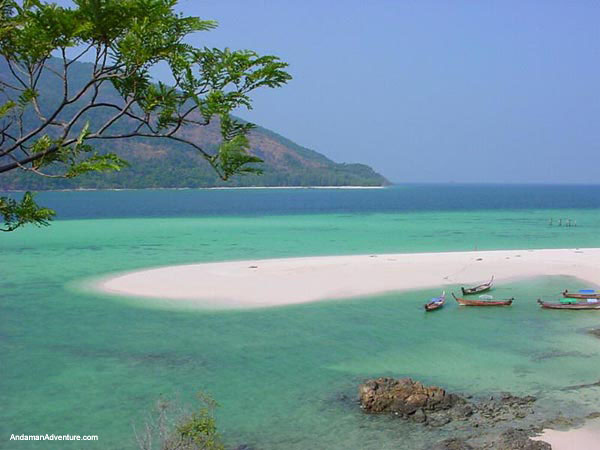
Topography
In general, the area, located the west of Phangnga Province, consists of sinking seashore and productive mud-beaches on estuaries of many long rivers. The area is influenced by ebb and high tide of the sea. There are high mountains and islands lie north and south such as, Ra Island with the mountains about 235 meters above sea level, Phra Island with plain area, Khor Island with high mountain about 310 meters above sea level, and many small islands such as Pling Island, Tachai Island and Borsai Island which has the highest mountain about 450 meters above sea level.

Climate
Ra Island and Phra Thong Island are situated close to each other. The area is in tropical climate. It has heavy rain all the year round because of being influenced by southeastern monsoon and northeastern monsoon. There are two seasons; rainy season starts from April to November with 2,124.7 mm. of rain all the year round and the highest rain in September with 366.2 mm. of rain; and summer starts from December to March, which also has some rain, with the highest temperature is 37.8 degrees Celsius in April and approximated temperature is 28.97 degrees Celsius.

Flora and Fauna
Plants
There are five types of forest follows a survey. Rain Forest: There is rain forest covered mountainous areas in Ra Island, foothill, and on th ridge which has its noted plants such as Yang, Suregada multiflorum Baill, the lower plants such as Mapring (a type of Anacardiaceae), Masan (a type of Dilleniaceae), Knema linifolia Warb, and shrub such as Licuala paludosa Griff, ratten, Pandanus etc.

  1. Mangrove Forest : There is mangrove forest along the seashores and in the bays which have been influenced by rivers and the ebb and high tide of the sea. When seeing aerial photograph, the mangrove forest is very long from Thung Nangdam Village southward to Khor Khao Island, Takuapa District. Plants found are small-leaf and big-leaf mangrove swamp, Samare Khao and Samare Dam (a type of Myrsinaceae), palmae such as Mangrove Date Palm and Oncosperma horrida Scheff, and shrub such as Finlaysonia maritima Back and Sea Holly.
  2. Beach Forest : There are beach forests in the areas that have never been covered by sea water in Ra Island and Phra Thong Island. Plants found are pine, tabebuia, Portia tree, Masan (a type of Dilleniaceae), Pandanus, and shrub such as beach morning glory.
  3. Replacing Plants : The tin mine in Phrathong Island makes the area unproductive. Plants found are paper bark tree clustered near ponds and scattered in plain area.
  4. Sea Grass : There is widespread sea grass in Thung Nang Dam Beach, from Visual Estimation Survey. The area is in the beach of Khura Estuary, in which the water is quite clear, extended to Nang Dam Beach. Between the beach and the seashore is a big pond suitable for sea grass so there have eight types of sea grass growing in the area about 1.38 squares kilometers, such as, by descending order, Cymodocea serrulata, Halodule uninervis H. ovalis, Syringodium isoetipolium, Enhalus acoroides, Halophrii and H. minor.

More over, there is sea grass growing in the east of Ra Island. Sea grass is very useful for example; it is the habitat, feeding area, breeding area and shelter of many kinds of sea animals such as shrimp, crab and fish, and of bigger animals such as sea turtle and dugong.

Now, sea grass is being deteriorated. Because there has been being fished by using some types of fishing devices and in the water has more sediment caused by the development of the land nearby. Therefore, that harms the sea grass and affects the sea animals. The best way to conserve the environment along the beaches is the government service should come up for strictly controlling using this area.

Wild Animals
From the exploration of all the islands in the area, the explorer divides the animals by their habitat and records the animals found by using binocular and asking information from local people as follows.
  • Mammals : From the elementary survey, the mammals found in this area are wild deer, wild boar, spectacled langur, crab-eating macaque, palm civet, smooth-coated otter, pangolin, plantain squirrel, gray-bellied squirrel, island flying fox, Malayan flying lemur, and island rat for examples.

    In addition, from the interview of local people and the survey of Polaris Plane, a slow speed airplane that flies only about 70-80 km. per hour and 200-1,000 feet high, in 100-200 squares kilometers of 8 areas in Phangnga Province, Krabi Province and Satun Province, between January 31, 1997 and April 10, 1997 shows that. There were 1-6 dugongs in Thung Nang Dam Village, Khura Buri District, Phangnga Province. And in July 23, 1998, local people had often seen dugongs trapped in fish stakes east of Ra Island and Thung Nang Dam Bay. That means there still are dugongs in the area. Now, dugong has rarely been found in the sea of Thailand because it is a sea-grass-feeding animal and an animal-for-food of fishermen. The more fishing boats are ef