
Koh Chang Information
| Koh Chang , in the Gulf of Thailand, a designated National Park, is approximately 300 kilometers south east of BangKohk. To prevent environmental damage the Government of Thailand has ensured that no roads will lead to Koh Chang . The island is connected to the mainland by ferries only. 
The largest island in the Koh Chang Marine Park archipelago, Koh Chang was named for the elephant shape of its headland, although elephants are not indigenous to the island. Best visited outside of the monsoon season -- which runs from about June to September -- the sea is warm and clear, the beaches for the most part white and sandy and the interior is filled with National Park protected forest and craggy, picturesque mountains. Most of the beaches are on the western coast, and each has built up with a distinctive atmosphere based on shopping, activities, partying or chilling out. Accommodation offers a style to suit every type of traveller, from independent low budget backpackers to those wanting a touch of luxury. There are plenty of activities to be organised from almost anywhere on the island: snorkelling and diving trips to nearby coral reefs, jungle treks and elephant rides, not to mention various beach sports. With it's long stretches of sandy beaches and bay, Koh Chang's west coast has become the focus of the development boom, and that's where most foreign travellers stay on the island. Beaches such as Haad Sai Khao (White Sands Beach), Khlong Prao and Kai Bae have developed more in the past few years than most of Thailand has in the last few decades. If you want to party, swim, dive or do practically anything else you'll find somewhere that's perfect for you. There are three different and definitive vibes from each of the three main west coast areas; White Sand beach, Kai Bae/Khlong Prao and Lonely/Bailan. White Sands is more modern than the others, reminiscent of Kuta in Bali, or indeed its aspired cousin, Phuket. The Kai Bae and Khlong Prao strip is gorgeous on the eye with its quaint village appearance, plenty of quirky shops and bars -- certainly more of a tropical island vibe. Lonely Beach and Bailan Bay continue on the topical island theme, but are far more traveller orientated; less souvenir shops, more bars playing Bob Marley. No Italian restaurants, but an abundance of affordable Thai fare. Ultimately it's a backpackers heaven. The east coast is home to major Thai villages but few beaches and so attracts far fewer foreign travellers. This side of the island is popular with Thais from cities such as BangKohk and Chiang Mai, who might never have seen the ocean before and want to join in traditional Thai seaside life. Sea Eagles, monkeys, epic views and jungle noises are all around, and if you're lucky you may spot the majestic Great Hornbill, resident of Koh Chang but rarely seen. Koh Chang is somewhere you can let your hair down a little, where perhaps those who hit the road in years gone by can capture the spirit of this wonder that we call travelling, yet enjoy the facilities that they yearn in today's society... namely air-con, hot water and a comfortable bed, and all found in abundance in White Sand, Khlong Prao and Kai Bae Beaches. At the same time, the old scene still exists at places like Lonely Beach, a reminder of what got the ball rolling in the first place. A word of warning, the roads on Koh Chang are treacherous. The steep gradient of the hills can be very dangerous, particularly during the rain, and every year there are fatal accidents; during our research through mid 2008, three people died in road accidents in one week -- serious statistics. If you're not an accomplished and experienced driver then this is not the island to start to learn. Cars and minibuses travel at breakneck speeds around the island and coupled with the hundreds of motorbikes whizzing about it becomes quite hazardous. Particularly bad stretches of road lead from the ferries to White Sand Beach, between Kai Bae and Lonely Beach, and the stretch from Bailan Bay to Bang Bao. With numerous hairpin turns up high on the cliff there is no room for mistakes. Taxis are a far better and safer option for getting about for the inexperienced. Also worth bearing in mind is that the clinic charges a 4,000B fee just to walk through the door for accident victims, even if all you need is a light bandage and some antiseptic.  Through the last decade, a wave of travellers, both international and domestic has washed over Koh Chang in ever increasing numbers, and its popularity will only continue to grow towards its government driven target of becoming the 'next Phuket'. That said, Koh Chang has much more of a tropical island feel than its larger cousin Phuket. Phuket Island is a province in itself, with an intricate network of villages and roadways -- Koh Chang didn't even have a main road ten years ago! Through the last decade, a wave of travellers, both international and domestic has washed over Koh Chang in ever increasing numbers, and its popularity will only continue to grow towards its government driven target of becoming the 'next Phuket'. That said, Koh Chang has much more of a tropical island feel than its larger cousin Phuket. Phuket Island is a province in itself, with an intricate network of villages and roadways -- Koh Chang didn't even have a main road ten years ago!
 Away from sun , sand & sea Koh Chang Away from sun , sand & sea Koh Chang
If you want to take a break from the Koh Chang beach, a wide range of activities await both on shore and inland.
 Thai Cooking Schools Koh Chang Thai Cooking Schools Koh Chang
If there's one thing visitors can take back with them, it's the remembrance of Thai cuisine. Nowadays, it's easy enough to re-create a lot of your favourites dishes since most Thai ingredients can be easily obtained or substituted. Such knowledge is given at most Thai cooking schools including the one at the Koh Chang . Classes take a few hours and students usually learn the art of fruit and vegetable carving as well as traditional stir-fried dishes. You will have an opportunity to cook by yourself and dine with fellow students after class.
Thai cooking as now enjoyed all over the world is a blend of Asian and European influences adopted through centuries of trade and diplomatic exchanges. Thais have traditionally lived close to the land and the waters, and original Thai cooking reflected that. Main ingredients were rice, fish, vegetable and herbs. Very little meat was used, and traditionally beef or buffalo meat was eschewed since the animals were the mainstays of farm life. |  Elephant Trekking Koh Chang Elephant Trekking Koh Chang
During harvest seasons in March/April, and in August/September, visitors are allowed to pick ripe pomelos from the trees with compliments of Chutiman, the proprietor. On your return route, the mahout may lead the elephant through a different path that exposes you to wild vegetation, giant trees and wildlife. Cold drinks and coffee are served as you refresh back at the camp. If you don't have time, you can still experience the thrill of a one-hour trek (500 Baht) without the waterfall. Open daily from 8.00 am to 5.00 pm, you can start your tour any time of the day.
The main road west of Koh Chang from Klong Son to Kai Bae is a popular route. The Kai Bae to Bang Bao hike is a challenging experience. Passing through some coconut groves and rubber smallholdings the terrain is steep. Shorter hikes to the waterfalls from their main entrances are gaining popularity. There are footpaths to the waterfalls. There are two Elephant Camps on Koh Chang. One in Klong Phrao is Chang Chutiman Company and one in a jungle valley in the north of Koh Chang. Ban Kwan Chang or the Klong Son Elephant Camp is supported by the Asian Elephant. Foundation to provide a natural environment for elephants and their mahouts (Kwan, in Thai). The camp opens with a half-day tour from 8.30 a.m. to 11.30 a.m. which include elephant bathing, feeding, performance and a 1.30 hour elephant trek into the forest. Elephant Trekking is fun. Come and enjoy, see how to take care Elephants and see how they work with them. Go on a Jungle ride and finaly wash the Elephant in a clear jungle stream. The cost is 900 Baht inclusive of transportation to and from your resort, your drinking water and bananas & coconuts for you to feed the elephants.  Snorkeling & Diving Koh Chang Snorkeling & Diving Koh Chang
The best diving season is between October/November and April. The best sites are on the west and southern tip of the island, between Koh Chang ( Koh Chang ) and Koh Kohod ( Koh Kut ). There you can see soft corals, anemones, myriad reef fish, and sometimes eel. Hin Luk Bat and Hin Lap both have coral seamounts. Further south, white-tip reef sharks can be found near Hin Phrai Nam.
| In addition, there are two wreck dive sites. The Koh Chang ( Koh Chang ) Wreck is a Thai warship sunk by the French navy in 1941. The wreck is only 15 metres deep in the Salakphet Bay on the southern tip of the island. The other wreck is the Pak One Wreck which sank after hitting a coral reef in August 1996 on its way to Vietnam. It resurfaced almost 8 years later. The 900-ton sunken tanker posed a danger to ships on international waters. The Royal Thai Navy drained off its 600 tonnes of liquefied petroleum gas and resank it between Koh Chang and Koh Samet. It now lies horizontally in 35-metre-deep waters. There are a few diving centres on Koh Chang ( Koh Chang ) such as the Ploy Scuba Diving in Bang Bao. They provide free transfer to and from the resort. Language barrier is no problem to the centre since they provide instructions in different languages. Following the standards of the sister centre in Koh Samet, this is the premier diving operator in Eastern Thailand. The best time to go snorkeling is also between October and May. There are beautiful snorkel places with shallow depths around Koh Chang. Such as Koh Wai, Koh Kra and Koh Rang. During high season we offer 4-5 day trips weekly. All trips start in the morning, including lunch. You will be back before sunset. |
| Canoes and Kayaking Koh Chang
For a relaxing trip along the coastlines, try paddling canoes. Canoes can be found along the beaches and some Koh Chang resorts. Viewing Fireflies Koh Chang
During the cooler months on Koh Chang ( Koh Chang ), you can rent a boat to slowly cruise along the waters at night to see fireflies in the mangroves. Thousands of fireflies send out mating signals as they settle into the mangrove forest, lighting up the whole tree with their simultaneous flashing in the dark. It's like rows of Christmas trees.  Klong Plu Waterfalls Koh Chang Klong Plu Waterfalls Koh Chang
One of the best-known waterfalls, Klong Plu is close to Klong Phrao and Kai Bae beaches. The fall plunges down a narrow drop-off into a pool, where you can go for a refreshing swim. Heading 3 km south from Klong Phrao along the main road, you will see a sign of the waterfall on the left. Turn left into the path and follow the sign for 2 km. You'll find a ticket kiosk to pay the entrance fee. Walk along a well-marked footpath for only 20 minutes or about 400 metres past many kinds of vegetation, birds and giant trees, and you'll encounter a spectacular view of the waterfall.
This is also a 3-level waterfall, which has served as an important source of fresh water for the island. King Rama V visited Klong Plu twice. Most visitors stay at the first level which is already a breath-taking sight. Walking to the second and third levels will need the assistance of park officials or guides, as the path is slippery and difficult to reach. Swimming and camping are allowed. Klong Plu Waterfall has three stories. The entrance is 3 Km. from Ao Klong Phrao Community. It will take about 20 minutes from the entrance to the site by walking. Klong Nueng Waterfall is a small fall situated remotely from Salak Petch Community near Salak Petch Waterfall. Klong Son Bay which is rich with coral lines is in the northernmost of the west |
| Other Activities Koh Chang
|
The Shrine of Jao Po Koh Chang
Leading up a steep road on the west coast to Ao Sapparos, not too far from the pier, you will see the shrine of Chao Po and Chao Mae Koh Chang on the right.
This is a highly revered shrine especially for local people. Chao Po Koh Chang (literally the Deity of Koh Chang) has guarded people on Koh Chang (Koh Chang), nearby islands and the mainland of Trat for generations. Fishermen struck by monsoon or lost their directions in the sea put their faith on Chao Po Koh Chang. Legend has it that many prayers have been answered, and the locals have been praying to Chao Po Koh Chang concerning various hardships, from low yield harvests to sickness or other miseries.
 Koh Kood
Situated 80 kms southeast of the provincial capital of Trat, Koh Kohod is the farthest island from the mainland. It is also the easternmost island of Thailand bordering Kampuchea. With an area of 129 sq. kms Koh Kohod is the second largest island of the Koh Chang Marine National Park and fourth largest in Thailand, after Koh Samui. It is supported by essential infrastructure, which include a hospital, schools, police station, electricity (mainly for state-run facilities), water and telephone system. Fuel and solar energy are, the main sources of electricity here. Most resorts generate their own electricity.
 Koh Rang
To the west of Koh Mak is a group of 12 islands known as the Moo Koh Rang. Of these, Koh Rang Yai is the largest. It is covered with tropical virgin rainforests and boast of the longest and most beautiful beach in the area, the Had San Chao or San Chao Beach, where the sand is powdery white and water crystal clear. Divers can enjoy its scenic underwater beauty up to 25 meters deep. Koh Rang Yai has a hilly terrain. Its only low-lying area are at the shores. Koh Rung is a small island at the west of Koh Maak. The isle has not enough flat area suitable for the setting up of any resort and bungalow. Koh Rung is place of concessions of bird nests, Charmed eggs and bat's dung. Stone knolls and deep-water coral under the sea of Koh Rung are very magnificent.
 Koh Mak
Lying between Koh Chang and Koh Kohod, about 40 km from the mainland is a group of 9 islands called the Moo Koh Mak (Moo Koh Maak). Only 4 of these islands, including Koh Maak, Koh Kradard, Koh Kham and Koh Rayang Nok are occupied. Koh Mak, with an area of only 16 sq km and a 27 km coastline, is the third largest island of the Marine Park. It has a flat terrain with plenty of coconut and rubber plantations. The main attractions are the long beaches and clear seawaters. There are only a few hundred people living here, most of them related.
Just 1 km northwest of Koh Mak is Koh Kham, a small island with clear seawater, coral reefs and coconut-fringed sandy beaches that are excellent for swimming, snorkelling, fishing and angling for squids. The island is almost within swimming distance from Koh Maak's Ao Suan Yai beach. Aged lava exists on the island which means a volcano existed in prehistoric times. Big boulders believed to be volcano rocks are seen on its pristine beaches. During low tide a sand dune practically links the island to Koh Mak (Koh Maak)...read more »
Naval Battle Area is in the south of Koh Chang close to Salak Petch Bay. The zone is where the battle between Thai and French naval troops fought over the east border conflict on January 17, 1941.
 Tan Mayom Waterfall is the three stories fall of medium size. The footpath up to the site, situated 500 meters from durian orchard, is near the office of the national park. King Rama V and VI once visited the place and singed their royal names on the highest cliff of the cascade.
Than Mayom Beach is a nice beach near the Than Mayom Waterfall which this waterfall is the most beautiful of Koh Chang. The waterfall there are the fresh water all the year and good place for swimming. This beach is good place for the travelers like the nice beach and nature life of waterfall.
 Klong Nonsi Waterfall is a little fall in the northeast zone of the island. The side- walk to the area lies 3 Km. from Baan Daan Mai or 3 Km. from the national park office.
Koh Chang Noi and Leam Chang Noi lie in the north of Koh Chang. The sea between Koh Chang Noi and Laem Chang Noi is abundant with corals.
Klong Son Community is set up in the area. Klong Plu Waterfall has three stories. The entrance is 3 Km. from Ao Klong Phrao Community. It will take about 20 minutes from the entrance to the site by walking.
 Klong Son Bay which is rich with coral lines is in the northernmost of the west coast. Klong Son Community is set up in the area.
Set at the northern tip of Koh Chang, Khlong Son gets very low numbers of visitors with the bulk of the backpackers and tourists alike speeding south enroute to Koh Chang's finer and more popular stretches of sand.
At a glance it is fairly easy to understand why that is the case as the beach here, particularly at low tide when it runs out to mud flats, is not much chop at all. It is isolated, and as long as you stay above the mud, it is pleasant enough for a late afternoon stroll, but that is about where the attraction ends.
There is also a fishing village at Khlong Son where you may be able to arrange a homestay should you be interested.
Situated northwest of Koh Chang, this is the first beach as you disembark and head west of the island. It is approximately 1.5 kilometres wide, at the southern part scarcely 2 kilometres long and at the northern section easily 3 kilometres. Had Klong Son is a wide beach with plenty of coconut trees. Two small islands are located at each end of Khlong Son Bay - Koh Chang Noi in the northwest and Koh Mapring in the southwest. This is popular with the fishermen as a port, since it is quite well protected against the violent winds during monsoon. The Premwadi Resort has a pier suitable for fishing and a powdery beach safe for swimming.
|  Tone Petch Waterfall has only one storey. The place is situated 3 Km. from Salak Petch Community along the orchard of rubber trees. White Sand Beach Tone Petch Waterfall has only one storey. The place is situated 3 Km. from Salak Petch Community along the orchard of rubber trees. White Sand Beach
 White Sand Beach This is Koh Chang's largest and longest and busiest beach. The beach is noted for its beautiful and fine white sand. Here you will find the shops, beach vendors and tourism related businesses. Boat charters, tours and motorcycle rentals can be arranged here. At the back or the beach are orchards of coconut trees and forests. The beach is easily accessible due to many roads passing to it The name suggests scenic beauty of the area. White Sand Beach This is Koh Chang's largest and longest and busiest beach. The beach is noted for its beautiful and fine white sand. Here you will find the shops, beach vendors and tourism related businesses. Boat charters, tours and motorcycle rentals can be arranged here. At the back or the beach are orchards of coconut trees and forests. The beach is easily accessible due to many roads passing to it The name suggests scenic beauty of the area.
White Sands Beach. The most popular and consequently the most densely touristed, the beach front is packed with concrete bungalows and upmarket resorts. At night the beach lights up with seafood barbecue restaurants on the sand and some funky beach bars. The main street that runs behind it, under the shadow of tree covered mountains, is likewise packed with restaurants, resorts, shops and tour agencies. If you're looking for a quiet secluded beach or budget accommodation this is not the spot, but of all the beaches on Koh Chang, Haad Sai Khao certainly has the most to offer in terms of variety and available amenities. It's hard to believe that just a few short decades ago there only a few places to stay, a dirt road and little to do in White Sands. There are a few quieter options at the northern end of the beach, based around and to the north of the small rocky outcrop where the last bastions of budget in the area are clinging on. It's old school, but decidedly pleasant. As development has driven prices up, the majority of the party crowd have upped and left for Lonely Beach; these places meanwhile are for the more laid back crowd who are on a shoestring... South of the rocky outcrop, things turn upmarket quickly. In this area the beach fills up every evening with on-the-sand restaurants, usually set up by the nearby resorts. Further south the beach turns rocky, so it's not great territory for reading a book on your beach towel, but with over two kilometres of sand to the north of you it's not hard to find a spot. A few of the resorts along the rockier stretch have man made beaches beside the pool. Heading further south the main road curves upwards and there is a decent cluster of bars and international restaurants at this end of town. Most of the beach bungalows and resorts also front onto the main road, and here's where you'll also find the dive shops, mini-marks, travel services and internet cafes. White Sands also has the biggest range of choice when it comes to banking services and shopping. White Sand Beach the longest and most popular beach on Koh Chang. It is about 2.5 kilometres long and lined by rocks, over-hanging palms and broad-leaved trees.The southern 1.5 kilometre long area, located at the road, is during the season the busiest part of the entire island. The main road runs pass all the resorts, shops, restaurants, pubs and coconut groves. It is the best place for those who enjoy the white wonderful sand and the association with other travelers: most visitors prefer coming to this beach that makes the beach so colorful.The beach slopes gently into the sea and is very wide during low tide attracting hordes of visitors, especially in the evening, when it transforms into a playground. Regular football and volleyball games are played as the sun sets right off its shore.  Haad Khai Mook Set between Whitesands and Klong Phrao, the small and pebble-strewn Haad Kai Mook (also known as Pearl Beach) is best known for the decent snorkelling available just off its shores rather than pristine white sands -- of which is has none. Haad Khai Mook Set between Whitesands and Klong Phrao, the small and pebble-strewn Haad Kai Mook (also known as Pearl Beach) is best known for the decent snorkelling available just off its shores rather than pristine white sands -- of which is has none.
A cheaper alternative to White Sands Beach to the north, accommodation here offers a lot better value for money, but without either the soft white sand nor the local amenities. If you have your own transport Haad Kai Mook is a great option, but if you're looking for quality (sandy) beach time or a raging nightlife, try either Kai Bae or Lonely Beach.  Bang Bao Fishery Village This beach is southwest portion of the island. The beach here lines the beautiful bay. There are a few fishing villages in this area. This is another one of Koh Chang's pristine locations, is very interesting because residents in the area build up their houses with poles pitched into the sea and the bridge reaching to every house is set up to link the community together. Bang Bao Fishery Village This beach is southwest portion of the island. The beach here lines the beautiful bay. There are a few fishing villages in this area. This is another one of Koh Chang's pristine locations, is very interesting because residents in the area build up their houses with poles pitched into the sea and the bridge reaching to every house is set up to link the community together.
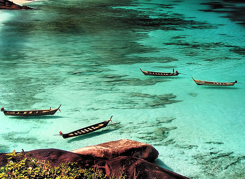
Bang Bao is the island's diving mecca and a jumping-off point for other islands in the area. Tourism has all but replaced fishing as the village's main industry, but it's still not so busy as the beaches in the north and Bang Bao retains a laid-back, breezy feel to it. Most of the action is on a long pier stretching out into the same-named bay. The pier is lined with private houses, shops, restaurants and guesthouses -- all on stilts; until about half way out. Beyond that the pier has been extended in recent years to allow for larger boats to moor safely. Once the morning madness has subsided and the dive/snorkel boats have embarked for the day, Bang Bao can make for a pleasant place to unwind -- the end of the pier sports a cute light house and stunning views looking back to the island, and the abundance of Sea Eagles diving for sprats in the shallows are a photographer's dream. Time and an over-abundance of travellers and day-trippers have resulted in Bang Bao shifting from being a fairly charming little fishing village into a bit of a tourist trap with overpriced seafood restaurants and no shortage of trinket shops. Despite this rising commercialism, Bang Bao remains interesting -- at least for a short visit. There is a photogenic collection of colourful fishing boats moored at the end of the pier, both genuine working boats and those for tourists' pleasure. A number of restaurants specialise in freshly caught seafood, though watch your wallet as prices can be very high; most places display a menu out front so be sure to have a browse if you are budget conscious. Aside from eating, other activities include fishing, snorkelling and diving boat trips -- there's even a real estate broker here. To the south-east of the pier area are a few lovely stretches of quiet beach. In front of the gallery at D.Jambe House is a very cute but diminutive beach the locals have recently started calling Haad Sai Noi -- there's a simple bar/eatery here which does good trade but no accommodation. Keep on another km or so and cross a narrow bridge over a lagoon and you're at another beach, Kohng Gloi. Kohng Gloi is one of the area's highlights, and the beach has a few huts where you can get a massage and have a snack underneath the palm trees. The beach looks over neighbouring islands and back to the pier at Bang Bao. The beach is very narrow at high tide, with barely a few metres to walk on. However venture here on one of those days when the tide is low all day and you'll be in for a treat, particularly if you value seclusion. There's a small motorbike lay-by for parking on the opposite side of the road from the bridge. Carry on a few km down the road and you'll eventually come to the sprawling metropolis of the Grand Cabana Resort. Orientation
Bang Bao is a small place, and you'll find just about all the services you could need on the pier. Internet shops are found on the pier, (1-2B a minute) and a few of the cafes around the square have a computers available. There is also a couple of ATM machines, the easiest to find is the one at the entrance to the pier, where there is also a money changer. Bang Bao is connected to the rest of Koh Chang by songthaews. They arrive and depart from the base of the pier, in the small town square. Bang Bao is one of the zones rich with corals. Koh Mun- Nok & Mun Nai is a small isle opposite Kai Bae's Beach. The Beach around the isle can be seen at low tide. The sea in the area is some what shallow and plenty of gold-colour corals. Bang Bao Bay is a well protected bay at the southwest end of Koh Chang. The quaint fishing village Baan Bang Bao is built on stakes far out into the bay and has become quite a popular attraction. Many seafood restaurants offer a rich selection of fresh seafood and small shops sell souvenirs or refreshments. Bang Bao Bay has lately become a resort and recreation area with bungalows built on selected scenic sites. The beach at Bang Bao has clear waters with rocks and corals off its shores. A good place to fish, snorkel and swim. |
 Salakphet Bay
With hardly any sandy beaches and a more erratic transport system, the eastern coast of the island is visited by far fewer foreign travellers than the western coast. Most of the places to stay are in the south-east, in the villages of Salakphet, Jek Bae and the newly established Long Beach. The largest village, Salakphet, does not receive so many visitors and so it is less developed and commercialised than Bang Bao. Life for the welcoming locals revolves around fishing, eating and getting away with as little other work as possible. The town is quite spread out over flat terrain, ringed with mountains, and the bay on one side. Perfect for getting about on motorbike.
It is situated on the south of island around Ao Salak Petch (Salak Petch Bay) which is the largest bay on Koh Chang. Salak Phet measures 3 kilometres in length and is between 1.5 and 2.5 kilometres wide. The villagers are mostly fishermen. Ao Salak Petch is an ideal shelter for fishing boats. There are many piers that serve fishing boats as well as boats to neighbouring islands and Laem Ngob. Beautifully, the islands Koh Mapring, Koh Phrao Nai and Koh Phrao Nok are situated in the mountain-surrounded bay. 3 villages, Baan Rong Than, Baan Salak Phet and Baan Chek Bae, find protection in the bay. They are built mostly on stakes into the sea and are inhabited by fishermen, rubber- and coconut-farmers.
 Salak Khok
Any exploration of the area wouldn't be complete without a visit to Salak Khok. A pint-sized fishing village that screams authenticity, houses are built along a series of boardwalks that snake around the canals of a mangrove forest. Red and aqua-painted fishing boats line the boardwalks and you stroll around gives the feeling that you've really discovered something special and unique. It's an incredibly pretty, unspoiled area.
A new business in Salak Khok has just started to rent out kayaks that you can use to go exploring in the mangrove forest. It's 100B for an hour's paddle or 200B if you want a guide along. The business also has a few traditional Thai row-boats in which you can enjoy a romantic Thai dinner while being rowed around the mangrove forest. It's like a strange juxtaposition of the Amazon Rainforest meets the canals of Venice. The dinner costs 1,200B. For more details call (01) 9193 995.
Dan Mai
Dan Mai is the largest Thai village on the island and is roughly half-way up the east coast. It's the home of services such as the BangKohk Koh Chang Hospital, the island's central police station and national park office. Internet access is limited and there aren't any ATM's on this side of the island, so get sorted out before you arrive.
Long Sand Beach is next to Sa Lak Kohk Bay. The area is covered with forest and orchards of coconut trees.
Long Beach isn't actually all that long, but it's beautiful and virtually untouched an has recently become a new hippy haven thanks to a relocation of Treehouse from Lonely Beach. Long Beach is a long way from anywhere and Treehouse management hope that will prevent the beach, as many people fear is happening to the western beaches overdevelopment (though this concern doesn't appear to have stopped them from constructing dozens and dozens and dozens of bungalows themselves).
Some of the best views on Koh Chang can be had on the road that links Long Beach with Salakphet, revealing breathtaking scenes of the bay and its few tenant teardrop islands.
 Lonely Beach
Rising popularity and rapid expansion means that Lonely Beach is lonely no more and traditional bamboo beach huts sit flush with expensive resorts. Like the rest of Koh Chang, Lonely Beach has gone ahead in leaps and bounds in the past few years, but it's still a chilled-out, laid-back little place with a village atmosphere -- by day at least.
By night is a different matter -- things get pretty raucous with parties tend to spring up randomly on any given day; so bear this in mind when choosing the location of your accommodation. Some people have started to call this place the Haad Rin of the East, (Haad Rin being the home of the Full Moon Party and related hedonism). With the ever more frequent party scene developing fast, the emergence of some very funky parties as well as the newly opened Vitamin Club, it certainly looks to be following in Haad Rin's footsteps. Light sleepers beware!
A collection of shops along the main road are set in a scenic spot between the steep, jungle-decked hills and the mostly rocky coastline. The road veers upwards and away from the beach as you head south through the town, so it's a downhill walk to go for a swim. Just north of the ever-popular backpacker hangout Treehouse is where the real beach begins, already taken up with several expensive resorts.
From the Treehouse southwards, the coastline is all rocks. It looks quite rugged and beautiful but isn't really suited for swimming. There are regular fire-shows on the beach where talented locals and a few game tourists tempt their luck by swinging alight balls on the ends of chains, called pois, around their heads.
Lonely Beach is an enclave of simple beach huts, sporadic generator electricity, and limited running water. The best day really depends on the person. You can bask in the sun while intermittently slipping into the beautiful ocean, spend a few hours sea kayaking along the rugged coast, embark on a day in the jungle, or get a taste of how Thai people truly live in one of the small fishing villages populating the area. Lonely Beach provides the opportunity to indulge in every imaginable aqua activity while at the same time being content with a good book.
 Bailan Bay
One of the few truly peaceful hideaways on Koh Chang's west coast, Bailan Bay is perhaps taking over where Lonely Beach has left off. The rocky bay has less to offer in terms of beach activity, but the chilled out atmosphere and secluded bungalows make for a tranquil and private spot to relax. There's a small strip of sandy beach at the northern end of the bay, but that's about all. Low-tide reveals a rocky landscape that extends hundreds of metres from the shore, giving the bay a unique character.
Bailan Bay is mainly for people who want to get away from all the hustle and bustle, and many people stay for a month or more. Things are about to get busier, though, with the massive Dusit resort newly opened at the southern end of the bay and plans for a shopping plaza.
Currently there's only one small grocery shop and a few independent Thai eateries along the main road. All accommodation options have their own restaurants. Bailan Bay is a short songthaew ride south of Lonely Beach, or about a 15 minute walk.
 Klong Phrao Beach This beach is south of the Hat Sai Khao beach, and it is not a busy beach. The bay, tropical vegetation and beach-line are very beautiful. There is a nearby fishing village, but not many services. ( Hat Khlong Phrao ) Laem Chaiyachet is the long seaside adjacent to Kai Bae Beach. The beach is rather steep. The northern most of the each which has beautiful landscape but swimming is not recommend.
Klong Phrao, or Coconut Canal, has sprung up in recent years as a centre for major upmarket resorts and health spas. The mostly private expanse of beach is quite narrow, particularly when the tide is in, but is covered with soft white sand.
Klong Phrao is strung out over about five kilometres of beach of varying quality. Though there are plenty of shops around VJ Plaza at the Chai Chet end, there's no feeling of a centred community here like on White Sands Beach or Kai Bae. The emphasis is on top-end resorts that cater for their guests' every whim. Much of the northern end of the beach is privately owned.
Despite the proximity to the water, many of the larger resorts have stunning swimming pools and because most of the accommodation is resort style, there are not too many independent restaurants or other shops in the area.
A highlight of a stay in Klong Phrao is a visit to the canal at night to see masses of fireflies dancing around in the twilight. As well as the usual beachside activities, there are a few excellent cooking schools towards the southern end of the beach. Klong Phrao is also the place to access the Khlong Phu waterfall and Chang Chutiman Trekking elephant camp.
Klong Phrao Beach starts where the gently curving Laem Chaichet ends. Coconut trees line the beach, and the northern end has a beautiful rocky landscape. Resort development has grown rapidly, although the beach itself does not get very crowded. Between White Sand Beach and Klong Phrao Beach is the 18-unit Remark Cottage , built with natural materials that mix with its secluded environment. The resort is outstanding for its traditional Thai spa and massage by well-trained staff. The Coconut Beach Resort has a variety of units which include the very simple wooden huts raised from the sandy beach by stilts at the seafront, the fanned bungalows and the air-conditioned bungalows with a refrigerator and a TV. VIP rooms by their new beachside swimming pool were recently open. The upmarket Koh Chang Resort & Spa provides packages for three days and two nights including meals and round-trip transfer from BangKohk. The bungalows have air-con, hot water, and satellite TV. The luxurious Klong Phrao Resort has cottage-styled rooms of different sizes, bungalows around a lagoon, VIP rooms by the pool and beach and a conference room for up to 200 people. Its long and wide beach is ideal for a leisurely walk or athletic activities. There is also a two-storey house that can hold up to 15 people.
Panviman Koh Chang Resort , a very pleasant hideaway, offers unique Asian architecture featuring three-tiered roof of reddish brown tiles. In addition to the swimming pool, there are the Jacuzzi and sauna. The 50-villa resort has been successful in attracting many European travelers, who usually spend a week to three weeks there. Rooms have wooden floors and four-poster beds. Another spa place is now located in the V.J. Hotel & Health Spa . Guests can enjoy the many contemporary comforts the hotel has, including a swimming pool and restaurant on the beach. The 39 boutique-style villas at Barali Beach Resort is nearby as with two other more upscale accommodations on this strip of beach. The Magic Resort on Klong Phrao Beach has bungalows for up to four persons but larger ones sleep up to five. The pride of Magic Resort is its beachfront restaurant built over a bay.
This is another long sandy beach. They are situated south of White Sand Beach. Klong Phrao Beach, growing rapidly into popularity after White Sand Beach. The area is covered with coconut grooves and wild vegetation. At the northernmost part of the beach is the rocky Laem Chaiyachet or Chaiyachet Cape which is an ideal site to watch the magnificent sunset or the sunrise above the southern hills of Bang Bao. Laem Chaiyachet is a favourite on-shore fishing ground. A fishing pier is erected near the cape which is also a great viewpoint for the whole of Klong Phrao Bay. The road runs almost everywhere in suitable distance from the beach and accommodation. Two small islands, Koh Suwan and Koh Rom are located at the southern end of Klong Phrao Beach.
 Kai Bae Beach is close to Klong Phrao Beach. The beach, like that of Klong Phrao, is steep but swimming is safe.
Kai Bae has become one of the better areas on Koh Chang for those wanting a bit of excitement, nightlife, restaurant options and easy access to tourist services. While not as busy and developed as Haad Sai Khao, Kai Bae is upgrading fast.
Kai Bae's beach is decent, with a range of accommodation from budget huts through to upscale resorts, and the main street is busy with bars, restaurants and shops, while the town itself is divided by a low, narrow bridge. On either side are clumps of mostly unnamed bars in small bamboo huts from which ladies and lady boys will becKohn you to come in from the street before charging 100B or more for a beer.
There's rarely a footpath, so pedestrians are forced to share the road with the traffic. The town was built on a platform of red clay that turns very muddy after rain and makes getting to the beach a very sticky experience.
During low tide in the morning the water receeds about 50m from the string of bungalows along the shore, revealing a moonscape of moss-covered rocks. This is great if you want to wander out and spot the shallow sea life, but means it's not such a nice place to swim later on. You have to be careful you don't cut your feet or fall face-down on the submurged rocks.
From the northern end of the beach it's possible to walk across to an uninhabited island during low-tide.
Kai Bae Beach (Haad Kai Bae) is situated south of Klong Phrao Beach. It is an almost 2.5 kilometre-long beautiful sand beach, which is partially lined by over-hanging palms and broad-leaved trees. Beaches on the southern coast are also guaranteed of its beauty and tranquility. Like all beaches on the west coast Kai Bae- Beach is flat, but nevertheless all the time suitable for bathing. In the dryer months, at low tide however, one must walk up to 100 metres to the deeper waters. Four islands, Koh Yuak, Koh Pli, Koh Man Nok and Koh Man Nai, are idyllically placed in the bay. At low-tide Koh Man Nai can be reached by foot...
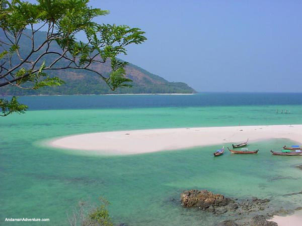
 Koh Lao Ya lies at the south of Koh Chang. The group comprises Koh Lao Ya Nai, Koh Lao Ya Klang and Koh Lao Ya Nok. The transportation from Laem Ngob takes about 2 hours and a half. The islands has beautiful beaches, crystal-clear water a cololurful corals, Lao Yo Resort provide accommodation service here.
Koh Wai situated next to Koh Lao Ya is a big island most of Beach which are plenty with stones. The area occupies many bay which has beautiful beach lines and wide wonderful coral zones. Koh Wai is also the best source for fishing. As for accommodations, Koh Wai Pakarung Resort is ready to server tourists.
 Koh Khlum is a historical island during the Thai-French Naval Battle like Koh Chang. The island is proper for fishing. The landscape comprising stone yard is worth a visit.
 Koh Phrao is in front of Salakpetch Bay from Laem Ngob, it takes two hours to the island, Koh Phrao has clean and calm seaside, and is cool and shady because it is plenty of coconuts trees.
 Koh Ngam is situated in the south of Koh Chang. The place comprises of two islands with a huge sand knoll at the middle. The little bay formed by the lines of the mountain stretching into the sea is a splendid and serene site without storms. It takes two hours to go from LaemNgob to the place.
Koh Chang Scuba Diving. A group of about 10 islands south of Koh Chang have coral reefs and are ideal for diving and fishing. Boats to the island can be hired from Ao Cho, Laem Sok Pier or Laem Ngop Pier that will take you to the islands where the diving is good. Diving season in Koh Chang is from October until May. The diving around Koh Chang is at reasonably shallow depths at 5 - 25 meters. Visibility is between 7 and 30 metes. There are fantastic reefs with a variety of corals. The main dive sites are Hin Luk Bat, Hin Sam Sao, Hin Raap and Koh Rang
Koh Chang Yoga, Wellness & Spa Treatments. In Asia, spa has evolved into a concept focussing on the spiritual and natural, drawing from traditions of meditation, respect for nature and the desire to achieve physical and mental well being, the key to maintaining health and beauty. In Thailand, the concept of spa blends with the ancient traditions of natural healing through herbal baths, massage, meditation, and the continued pursuit of inner and outer beauty. Before the arrival of modern medicine in Thailand, the temple was the the centre of learning for all disciplines, including medicine. Monks therefore played the role of doctor and pharmacist, prescribing herbal remedies, steam compresses, massages and other such treatments for the relief of various ailments. Spa therapy is another choice to feel relaxed and rid away your aching. Most up-scale hotels and resorts offer their unique therapeutic session.


 This group of rocks and islands lies 90 minutes by speedboat off the coast of Phang-Nga, or eight or more hours by slow boat from Phuket. The area was declared a marine national park in 1982 and consequently remains largely undeveloped. Derived from the Malay term sembilan, meaning 'nine', Similan refers to the nine main islands in the group.
